
Mapa topográfico Poros
Mapa interactivo
Haga clic en el mapa para ver la altitud.
Acerca de este mapa
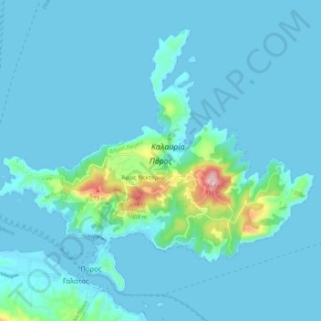
Nombre: Mapa topográfico Poros, altitud, relieve.
Altitud media: 31 m
Altitud mínima: -1 m
Altitud máxima: 351 m
The land area of the municipality (which includes the islands and part of the adjacent Peloponnese coast) is 49.582 square kilometres (19.144 sq mi). The landscape is very hilly and mountainous. The highest peak is the Vigla (358 m) in the west-central part. Following the island's topography and geology, small creeks and seasonal streams flow through steep valleys of the southern and northeastern part. The western and northern part of the island feature smooth hills and shallow valleys. Sandy beaches are restricted to the southern shore of the island, except for a bay in the northern part called Vayionia.