
Mapa topográfico McMinnville
Mapa interactivo
Haga clic en el mapa para ver la altitud.
Acerca de este mapa
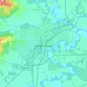
Nombre: Mapa topográfico McMinnville, altitud, relieve.
Lugar: McMinnville, Yamhill County, Oregon, 97128, United States (45.18565 -123.25450 45.23922 -123.12920)
Altitud media: 50 m
Altitud mínima: 25 m
Altitud máxima: 254 m
Otros mapas topográficos
Haga clic en un mapa para ver su topografía, su altitud y su relieve.
Newberg
United States > Oregon > Yamhill County
Newberg, Yamhill County, Oregon, United States
Altitud media: 61 m
Sheridan
United States > Oregon > Yamhill County
Sheridan, Yamhill County, Oregon, United States
Altitud media: 85 m
Lafayette
United States > Oregon > Yamhill County
Lafayette, Yamhill County, Oregon, 97127, United States
Altitud media: 52 m
McGuire Reservoir
United States > Oregon > Yamhill County
McGuire Reservoir, Yamhill County, Oregon, United States
Altitud media: 582 m
Bald Peak State Scenic Viewpoint
United States > Oregon > Yamhill County
Bald Peak State Scenic Viewpoint, Southwest Bald Peak Road, Yamhill County, Oregon, United States
Altitud media: 334 m
Carlton
United States > Oregon > Yamhill County
Carlton, Yamhill County, Oregon, 97111, United States
Altitud media: 51 m
Amity
United States > Oregon > Yamhill County
Amity, Yamhill County, Oregon, United States
Altitud media: 51 m
Dayton
United States > Oregon > Yamhill County
Dayton, Yamhill County, Oregon, United States
Altitud media: 43 m
Dundee
United States > Oregon > Yamhill County
Dundee, Yamhill County, Oregon, 97115, United States
Altitud media: 69 m
Willamina
United States > Oregon > Yamhill County > Willamina
Willamina, Yamhill County, Oregon, United States
Altitud media: 93 m
Yamhill
United States > Oregon > Yamhill County > Yamhill
Yamhill, Yamhill County, Oregon, United States
Altitud media: 55 m
Tetons
United States > Oregon > Yamhill County
Tetons, Yamhill County, Oregon, United States
Altitud media: 406 m