
Haz una donación
Mapa topográfico Marinette
Haga clic en el mapa para ver la altitud.
Haz una donación
Acerca de este mapa
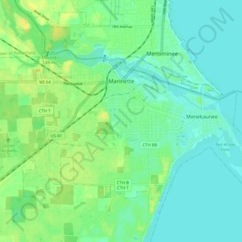
Nombre: Mapa topográfico Marinette, altitud, relieve.
Lugar: Marinette, Marinette County, Wisconsin, 54143, United States (45.06418 -87.67002 45.11332 -87.57386)
Altitud media: 182 m
Altitud mínima: 173 m
Altitud máxima: 198 m
Haz una donación
Otros mapas topográficos
Haga clic en un mapa para ver su topografía, su altitud y su relieve.
Marinette County Beech Forest State Natural Area
United States > Wisconsin > Marinette County
Altitud media: 371 m
McAllister
United States > Wisconsin > Marinette County
McAllister is located at the intersection of Wisconsin Highway 180 and County Highway JJ 11.5 miles (18.5 km) east-southeast of Wausaukee at an elevation of 692 feet (211 m). It is connected by road to Wausaukee to the west, Packard to the north, Wagner to the south, and Wallace, Michigan, to the east via a…
Altitud media: 210 m
Long Slide Falls County Park
United States > Wisconsin > Marinette County > Town of Niagra
Altitud media: 288 m
Haz una donación