
Mapa topográfico Onrus River
Mapa interactivo
Haga clic en el mapa para ver la altitud.
Acerca de este mapa
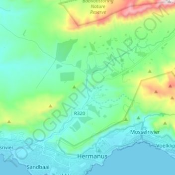
Nombre: Mapa topográfico Onrus River, altitud, relieve.
Altitud media: 232 m
Altitud mínima: -1 m
Altitud máxima: 1.149 m
Otros mapas topográficos
Haga clic en un mapa para ver su topografía, su altitud y su relieve.
Gansbaai
South Africa > Western Cape > Overstrand Local Municipality
Gansbaai, Overstrand Local Municipality, Western Cape, South Africa
Altitud media: 34 m
Hermanus
South Africa > Western Cape > Overstrand Local Municipality
Hermanus, Overstrand Local Municipality, Western Cape, 7200, South Africa
Altitud media: 87 m
Betty's Bay
South Africa > Western Cape > Overstrand Local Municipality
Betty's Bay, Overstrand Local Municipality, Western Cape, 7141, South Africa
Altitud media: 210 m
Stanford
South Africa > Western Cape > Overstrand Local Municipality
Stanford, Overstrand Local Municipality, Western Cape, 7210, South Africa
Altitud media: 107 m
Boskop
South Africa > Western Cape > Overstrand Local Municipality
Boskop, Overstrand Local Municipality, Overberg District Municipality, Western Cape, 7210, South Africa
Altitud media: 503 m
Three Sisters
South Africa > Western Cape > Overstrand Local Municipality
Three Sisters, Overstrand Local Municipality, Overberg District Municipality, Western Cape, 7195, South Africa
Altitud media: 306 m
Kleinmond
South Africa > Western Cape > Overstrand Local Municipality
Kleinmond, Overstrand Local Municipality, Western Cape, 7195, South Africa
Altitud media: 119 m