
Mapa topográfico Canmer
Mapa interactivo
Haga clic en el mapa para ver la altitud.
Acerca de este mapa
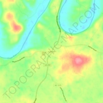
Nombre: Mapa topográfico Canmer, altitud, relieve.
Lugar: Canmer, Hart County, Kentucky, United States (37.27033 -85.78719 37.31033 -85.74719)
Altitud media: 185 m
Altitud mínima: 144 m
Altitud máxima: 240 m
Otros mapas topográficos
Haga clic en un mapa para ver su topografía, su altitud y su relieve.
Lone Star
United States > Kentucky > Hart County
Lone Star, Hart County, Kentucky, 42713, United States
Altitud media: 228 m
Uno
United States > Kentucky > Hart County
Uno, Hart County, Kentucky, United States
Altitud media: 201 m
Hardyville
United States > Kentucky > Hart County
Hardyville, Hart County, Kentucky, United States
Altitud media: 212 m
Jonesville
United States > Kentucky > Hart County
Jonesville, Hart County, Kentucky, 42757, United States
Altitud media: 241 m
Bee
United States > Kentucky > Hart County
Bee, Hart County, Kentucky, 42729, United States
Altitud media: 230 m
Big Windy
United States > Kentucky > Hart County
Big Windy, Hart County, Kentucky, 42729, United States
Altitud media: 206 m
Hammonville
United States > Kentucky > Hart County
Hammonville, Hart County, Kentucky, United States
Altitud media: 232 m
Northtown
United States > Kentucky > Hart County
Northtown, Hart County, Kentucky, United States
Altitud media: 225 m
Woodsonville
United States > Kentucky > Hart County
Woodsonville, Hart County, Kentucky, 42765, United States
Altitud media: 183 m
Munfordville
United States > Kentucky > Hart County
Munfordville, Hart County, Kentucky, United States
Altitud media: 191 m
Kessinger
United States > Kentucky > Hart County
Kessinger, Hart County, Kentucky, 42765, United States
Altitud media: 260 m
Rowletts
United States > Kentucky > Hart County
Rowletts, Hart County, Kentucky, United States
Altitud media: 197 m
Horse Cave
United States > Kentucky > Hart County
Horse Cave, Hart County, Kentucky, United States
Altitud media: 207 m
Bonnieville
United States > Kentucky > Hart County
Bonnieville, Hart County, Kentucky, 42713, United States
Altitud media: 212 m
Cub Run
United States > Kentucky > Hart County
Cub Run, Hart County, Kentucky, 42729, United States
Altitud media: 225 m
Monroe
United States > Kentucky > Hart County
Monroe, Hart County, Kentucky, 42746, United States
Altitud media: 210 m