
Mapa topográfico Brussels–Scheldt Maritime Canal
Mapa interactivo
Haga clic en el mapa para ver la altitud.
Brussels–Scheldt Maritime Canal
The difference in altitude of 14 m between Brussels and the Rupel river at Willebroek was achieved with 4 locks. With the commissioning of the canal, the ships could now avoid navigating the Zenne and being subject to tax in Mechelen.
Acerca de este mapa
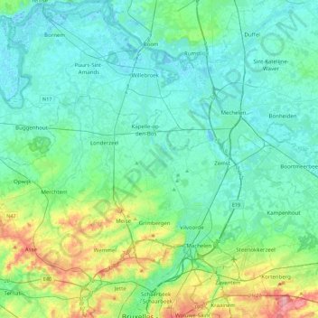
Nombre: Mapa topográfico Brussels–Scheldt Maritime Canal, altitud, relieve.
Altitud media: 22 m
Altitud mínima: -3 m
Altitud máxima: 110 m