
Mapa topográfico Beaver Island
Mapa interactivo
Haga clic en el mapa para ver la altitud.
Acerca de este mapa
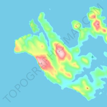
Nombre: Mapa topográfico Beaver Island, altitud, relieve.
Lugar: Beaver Island, Falkland Islands (-51.87863 -61.34800 -51.79528 -61.19575)
Altitud media: 24 m
Altitud mínima: -1 m
Altitud máxima: 238 m
Other islands in the group include Staats Island, with an area of 500 hectares (1,200 acres); Tea Island, which covers 310 hectares (770 acres); Governor Island, which covers 220 hectares (540 acres); Split Island, with an area of 70 hectares (170 acres) and a few smaller islands. Though the smaller islands in the group are low-lying, the larger islands are very hilly, with many peaks of more than 150 metres (490 ft) and some more than 200 metres (660 ft). The highest elevation in the Beaver Island Group is 234 metres (768 ft).
Otros mapas topográficos
Haga clic en un mapa para ver su topografía, su altitud y su relieve.
Johnson's Harbour
Falkland Islands > Johnson's Harbour
Johnson's Harbour, Falkland Islands
Altitud media: 15 m
Port Louis Harbour
Falkland Islands > Port Louis South
Port Louis Harbour, Port Louis Road, Port Louis South, Falkland Islands
Altitud media: 11 m