
Mapa topográfico Mornos Artificial Lake
Mapa interactivo
Haga clic en el mapa para ver la altitud.
Acerca de este mapa
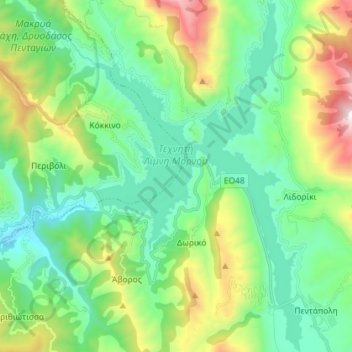
Nombre: Mapa topográfico Mornos Artificial Lake, altitud, relieve.
Altitud media: 672 m
Altitud mínima: 283 m
Altitud máxima: 1.708 m
Otros mapas topográficos
Haga clic en un mapa para ver su topografía, su altitud y su relieve.
Dytiki Soufla
Greece > Thessaly and Central Greece > Regional Unit of Phocis > Municipal Unit of Vardousia
Dytiki Soufla, Municipal Unit of Vardousia, Dorida Municipality, Regional Unit of Phocis, Central Greece, Thessaly and Central Greece, Greece
Altitud media: 1.893 m