
Mapa topográfico Batesville
Mapa interactivo
Haga clic en el mapa para ver la altitud.
Acerca de este mapa
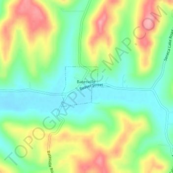
Nombre: Mapa topográfico Batesville, altitud, relieve.
Lugar: Batesville, Noble County, Ohio, United States (39.91032 -81.28638 39.91660 -81.27626)
Altitud media: 308 m
Altitud mínima: 258 m
Altitud máxima: 379 m
Otros mapas topográficos
Haga clic en un mapa para ver su topografía, su altitud y su relieve.
Caldwell
United States > Ohio > Noble County
Caldwell, Noble County, Ohio, United States
Altitud media: 247 m
Belle Valley
United States > Ohio > Noble County > Belle Valley
Belle Valley, Noble County, Ohio, 43717, United States
Altitud media: 251 m
Mount Zion
United States > Ohio > Noble County > Mount Zion
Mount Zion, Noble County, Ohio, 43772, United States
Altitud media: 274 m
Flag
United States > Ohio > Noble County
Flag, Noble County, Ohio, 43786, United States
Altitud media: 278 m