
Haz una donación
Mapa topográfico Bais
Haga clic en el mapa para ver la altitud.
Haz una donación
Acerca de este mapa
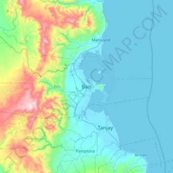
Nombre: Mapa topográfico Bais, altitud, relieve.
Lugar: Bais, Negros Oriental, Central Visayas, 6206, Philippines (9.43148 122.96130 9.75148 123.28130)
Altitud media: 176 m
Altitud mínima: -1 m
Altitud máxima: 915 m
Haz una donación
Otros mapas topográficos
Haga clic en un mapa para ver su topografía, su altitud y su relieve.
Santa Catalina
The topography of Santa Catalina is predominantly slightly rolling hills (70% of its area), 25% is flat, and the remainder is steep terrain. There are 8 rivers and 27 springs.
Altitud media: 143 m
Valencia
Valencia occupies an area of 14,749 hectares (36,450 acres), 35% of which are classified as plains. The town is 65% mountainous, with elevation averaging from 200 to 500 metres (660 to 1,640 ft) above sea level, with the top of Mount Talinis at an elevation of 1,903 metres (6,243 ft) along the municipal…
Altitud media: 367 m
Haz una donación