
Mapa topográfico Samos
Mapa interactivo
Haga clic en el mapa para ver la altitud.
Acerca de este mapa
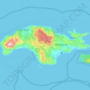
Nombre: Mapa topográfico Samos, altitud, relieve.
Lugar: Samos, Samos Regional Unit, Northern Aegean, Aegean, Greece (37.63610 26.56611 37.81311 27.06986)
Altitud media: 78 m
Altitud mínima: -1 m
Altitud máxima: 1.421 m
Otros mapas topográficos
Haga clic en un mapa para ver su topografía, su altitud y su relieve.
Manolates
Greece > Aegean > Samos Regional Unit > Municipal Unit of Vathy
Manolates, Municipal Unit of Vathy, Municipality of Eastern Samos, Samos Regional Unit, Northern Aegean, Aegean, 832 00, Greece
Altitud media: 435 m
Chora
Greece > Aegean > Samos Regional Unit > Municipal Unit of Pythagoreio
Chora, Municipal Unit of Pythagoreio, Municipality of Eastern Samos, Samos Regional Unit, Northern Aegean, Aegean, 831 03, Greece
Altitud media: 88 m