
Mapa topográfico Carroll County
Mapa interactivo
Haga clic en el mapa para ver la altitud.
Acerca de este mapa
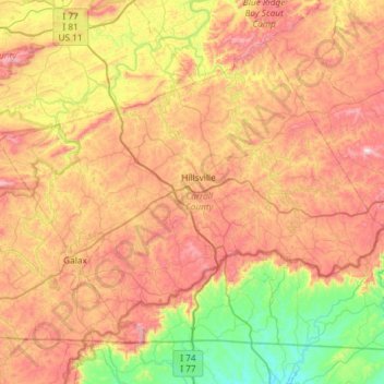
Nombre: Mapa topográfico Carroll County, altitud, relieve.
Lugar: Carroll County, Virginia, United States (36.55791 -81.04243 36.93178 -80.45377)
Altitud media: 709 m
Altitud mínima: 313 m
Altitud máxima: 1.181 m
It is the only county in Virginia with Piedmont topography of roughly one fifth in the southeast part of the county and mountain topography of roughly four fifths elsewhere of the county. The Blue Ridge escarpment usually defines the county lines in both North Carolina and Virginia. The CDP community of Cana is in the Virginia Piedmont while the rest of the county is in the Appalachian Mountains.