
Mapa topográfico Bouillon
Mapa interactivo
Haga clic en el mapa para ver la altitud.
Acerca de este mapa
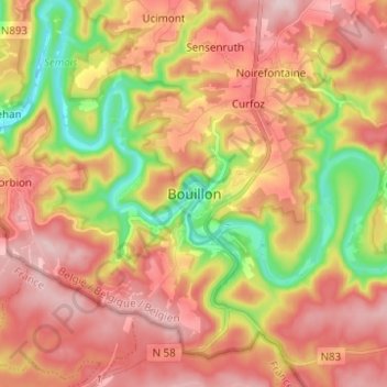
Nombre: Mapa topográfico Bouillon, altitud, relieve.
Lugar: Bouillon, Neufchâteau, Luxembourg, Wallonia, 6830, Belgium (49.75498 5.02725 49.83498 5.10725)
Altitud media: 338 m
Altitud mínima: 195 m
Altitud máxima: 447 m
Otros mapas topográficos
Haga clic en un mapa para ver su topografía, su altitud y su relieve.
Laviot
Belgium > Luxembourg > Neufchâteau > Bouillon > Rochehaut
Laviot, Rochehaut, Bouillon, Neufchâteau, Luxembourg, Wallonia, 6838, Belgium
Altitud media: 297 m
Frahan
Belgium > Luxembourg > Neufchâteau > Bouillon > Rochehaut
Frahan, Rochehaut, Bouillon, Neufchâteau, Luxembourg, Wallonia, 6838, Belgium
Altitud media: 291 m