
Mapa topográfico Bredasdorp
Mapa interactivo
Haga clic en el mapa para ver la altitud.
Acerca de este mapa
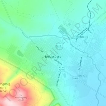
Nombre: Mapa topográfico Bredasdorp, altitud, relieve.
Altitud media: 101 m
Altitud mínima: 26 m
Altitud máxima: 364 m
Bredasdorp is situated at an elevation of between 40 and 120 metres (130 and 390 ft) on the slopes of the Heuningberg (Afrikaans for "Honey Mountain"). There is no significant watercourse flowing through the town, although the Kars Rivier flows past a few kilometres to the east.
Otros mapas topográficos
Haga clic en un mapa para ver su topografía, su altitud y su relieve.
Bredasdorp
South Africa > Western Cape > Overberg District Municipality > Cape Agulhas Local Municipality
Bredasdorp, Cape Agulhas Local Municipality, Overberg District Municipality, Western Cape, 7280, South Africa
Altitud media: 104 m
Arniston
South Africa > Western Cape > Overberg District Municipality > Cape Agulhas Local Municipality
Arniston, Cape Agulhas Local Municipality, Overberg District Municipality, Western Cape, South Africa
Altitud media: 13 m
Struisbaai
South Africa > Western Cape > Overberg District Municipality > Cape Agulhas Local Municipality > Molshoop
Struisbaai, Cape Agulhas Ward 5, Molshoop, Cape Agulhas Local Municipality, Overberg District Municipality, Western Cape, 7285, South Africa
Altitud media: 27 m
Skipskop
South Africa > Western Cape > Overberg District Municipality > Cape Agulhas Local Municipality
Skipskop, Cape Agulhas Ward 4, Cape Agulhas Local Municipality, Overberg District Municipality, Western Cape, South Africa
Altitud media: 10 m
De Hoop Nature Reserve
South Africa > Western Cape > Overberg District Municipality > Cape Agulhas Local Municipality
De Hoop Nature Reserve, Cape Agulhas Ward 4, Cape Agulhas Local Municipality, Overberg District Municipality, Western Cape, 7280, South Africa
Altitud media: 63 m
De Mond Nature Reserve
South Africa > Western Cape > Overberg District Municipality > Cape Agulhas Local Municipality
De Mond Nature Reserve, Gravel Road, Cape Agulhas Ward 6, Cape Agulhas Local Municipality, Overberg District Municipality, Western Cape, South Africa
Altitud media: 5 m