
Mapa topográfico Dehrn
Mapa interactivo
Haga clic en el mapa para ver la altitud.
Acerca de este mapa
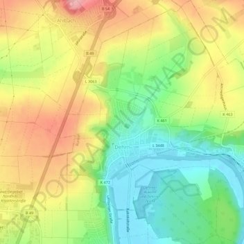
Nombre: Mapa topográfico Dehrn, altitud, relieve.
Lugar: Dehrn, Runkel, Landkreis Limburg-Weilburg, Hessen, Deutschland (50.40497 8.08354 50.44021 8.12188)
Altitud media: 172 m
Altitud mínima: 110 m
Altitud máxima: 242 m
Otros mapas topográficos
Haga clic en un mapa para ver su topografía, su altitud y su relieve.
Arfurt
Deutschland > Hessen > Landkreis Limburg-Weilburg > Runkel
Arfurt, Runkel, Landkreis Limburg-Weilburg, Hessen, Deutschland
Altitud media: 213 m
Eschenau
Deutschland > Hessen > Landkreis Limburg-Weilburg > Runkel
Eschenau, Runkel, Landkreis Limburg-Weilburg, Hessen, Deutschland
Altitud media: 209 m
Steeden
Deutschland > Hessen > Landkreis Limburg-Weilburg > Runkel > Steeden
Steeden, Runkel, Landkreis Limburg-Weilburg, Hessen, 65594, Deutschland
Altitud media: 158 m