
Mapa topográfico Evansville
Mapa interactivo
Haga clic en el mapa para ver la altitud.
Acerca de este mapa
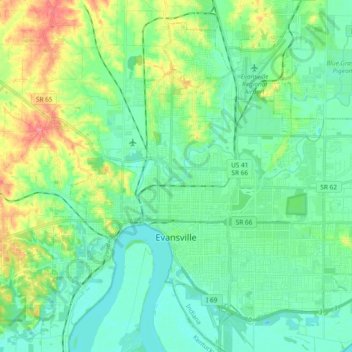
Nombre: Mapa topográfico Evansville, altitud, relieve.
Lugar: Evansville, Vanderburgh County, Indiana, United States (37.93559 -87.63755 38.05689 -87.44987)
Altitud media: 122 m
Altitud mínima: 105 m
Altitud máxima: 179 m
Otros mapas topográficos
Haga clic en un mapa para ver su topografía, su altitud y su relieve.
Country Club Meadows
United States > Indiana > Vanderburgh County > Evansville
Country Club Meadows, Evansville, Vanderburgh County, Indiana, 47710, United States
Altitud media: 126 m
Darmstadt
United States > Indiana > Vanderburgh County
Darmstadt, Vanderburgh County, Indiana, United States
Altitud media: 143 m