
Mapa topográfico Town of Newfield
Mapa interactivo
Haga clic en el mapa para ver la altitud.
Acerca de este mapa
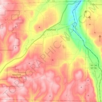
Nombre: Mapa topográfico Town of Newfield, altitud, relieve.
Altitud media: 426 m
Altitud mínima: 134 m
Altitud máxima: 634 m
Otros mapas topográficos
Haga clic en un mapa para ver su topografía, su altitud y su relieve.
Town of Danby
United States > New York > Tompkins County
Town of Danby, Tompkins County, New York, United States
Altitud media: 404 m
City of Ithaca
United States > New York > Tompkins County
City of Ithaca, Tompkins County, New York, United States
Altitud media: 195 m
Buttermilk Falls State Park
United States > New York > Tompkins County > Ithaca > Town of Danby
Buttermilk Falls State Park, Ithaca, Town of Danby, Tompkins County, New York, United States
Altitud media: 269 m
East Ithaca
United States > New York > Tompkins County > Ithaca > East Ithaca
East Ithaca, Ithaca, Tompkins County, New York, United States
Altitud media: 281 m
Town of Ithaca
United States > New York > Tompkins County
Town of Ithaca, Tompkins County, New York, United States
Altitud media: 288 m
Town of Dryden
United States > New York > Tompkins County
Town of Dryden, Tompkins County, New York, United States
Altitud media: 430 m
Waterburg
United States > New York > Tompkins County > Waterburg
Waterburg, Ulysses Town, Tompkins County, New York, 14886, United States
Altitud media: 318 m