
Haz una donación
Mapa topográfico Abbotsford
Haga clic en el mapa para ver la altitud.
Haz una donación
Acerca de este mapa
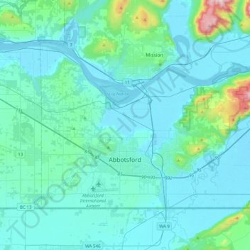
Nombre: Mapa topográfico Abbotsford, altitud, relieve.
Altitud media: 99 m
Altitud mínima: -2 m
Altitud máxima: 1.003 m
Haz una donación
Otros mapas topográficos
Haga clic en un mapa para ver su topografía, su altitud y su relieve.
Vedder Mountain
Canada > British Columbia > Fraser Valley Regional District > Chilliwack
Altitud media: 556 m
Minto Landing
Canada > British Columbia > Fraser Valley Regional District > Chilliwack
Altitud media: 19 m
Haz una donación
Cheam Peak
Canada > British Columbia > Fraser Valley Regional District > Area E (Chilliwack River Valley)
Altitud media: 1.471 m
Harrison River
Canada > British Columbia > Fraser Valley Regional District > Kent > Harrison Mills
Altitud media: 45 m
Sumas River
Canada > British Columbia > Fraser Valley Regional District > Abbotsford
Altitud media: 167 m
Pattinson Peak
Canada > British Columbia > Fraser Valley Regional District > Area F (McConnell Creek/Hatzic Prairie)
Altitud media: 762 m
Haz una donación
Chehalis Lake
Canada > British Columbia > Fraser Valley Regional District > Area C (Sasquatch Country)
Altitud media: 735 m
Sloquet Creek
Canada > British Columbia > Fraser Valley Regional District > Area C (Sasquatch Country)
Altitud media: 255 m
Haz una donación
Whippoorwill Point
Canada > British Columbia > Fraser Valley Regional District > Harrison Hot Springs
Altitud media: 115 m
Mount Barr
Canada > British Columbia > Fraser Valley Regional District > Area D (Popkum/Bridal Falls/Wahleach)
Mount Barr is a mountain in the Skagit Range of the Cascade Mountains of southern British Columbia, Canada, located on the northeast side of Wahleach Lake and just southwest of Hope. It is a ridge highpoint with an elevation of 1,907 m (6,257 ft).
Altitud media: 1.414 m
Lindell Beach
Canada > British Columbia > Fraser Valley Regional District > Area H (Cultus Lake/Columbia Valley)
Altitud media: 268 m
Haz una donación
Jones Lake
Canada > British Columbia > Fraser Valley Regional District > Area D (Popkum/Bridal Falls/Wahleach)
Altitud media: 956 m
Harrison Mills
Canada > British Columbia > Fraser Valley Regional District > Area C (Sasquatch Country)
Altitud media: 95 m
Mount Garibaldi
Canada > British Columbia > Fraser Valley Regional District > Area F (McConnell Creek/Hatzic Prairie)
Mount Garibaldi (Squamish: Nch'ḵay̓, pronounced [n̩.ʧʼqɛˀj̰]) is a dormant stratovolcano in the Garibaldi Ranges of the Pacific Ranges in southwestern British Columbia, Canada. It has a maximum elevation of 2,678 metres (8,786 feet) and rises above the surrounding landscape on the east side of the…
Altitud media: 2.146 m
Hemlock Valley
Canada > British Columbia > Fraser Valley Regional District > Area C (Sasquatch Country)
Altitud media: 1.106 m
Haz una donación
Canyon Alpine
Canada > British Columbia > Fraser Valley Regional District > Area A (Boston Bar/North Bend/Canyon Alpine)
Altitud media: 471 m
Sunshine Valley
Canada > British Columbia > Fraser Valley Regional District > Area B (South Fraser Canyon/Sunshine Valley)
Altitud media: 1.030 m
Spuzzum
Canada > British Columbia > Fraser Valley Regional District > Area B (South Fraser Canyon/Sunshine Valley)
In 1956–57, contracts were awarded for the replacement of Spuzzum Creek bridge and associated roadwork, lying west of and higher than the railway bridge. In 1957–58, this work was completed. Once the new Alexandra Bridge opened in 1962, the highway bypassed Spuzzum at a higher elevation and the second…
Altitud media: 451 m
Haz una donación
Abbotsford
Canada > British Columbia > Fraser Valley Regional District > Abbotsford
Altitud media: 115 m
Lindell Beach
Canada > British Columbia > Fraser Valley Regional District > Area H (Cultus Lake/Columbia Valley)
Altitud media: 191 m
Haz una donación
Elk Mountain
Canada > British Columbia > Fraser Valley Regional District > Chilliwack
Altitud media: 1.009 m
Airplane Basin Falls
Canada > British Columbia > Fraser Valley Regional District > Area E (Chilliwack River Valley)
Altitud media: 1.487 m
Popkum
Canada > British Columbia > Fraser Valley Regional District > Area D (Popkum/Bridal Falls/Wahleach)
Altitud media: 101 m
Ibex Peak
Canada > British Columbia > Fraser Valley Regional District > Area B (South Fraser Canyon/Sunshine Valley)
Altitud media: 1.550 m
Haz una donación
Cultus Lake
Canada > British Columbia > Fraser Valley Regional District > Area H (Cultus Lake/Columbia Valley) > Cultus Lake
Altitud media: 191 m
Serpentine Lake
Canada > British Columbia > Fraser Valley Regional District > Area B (South Fraser Canyon/Sunshine Valley)
Altitud media: 960 m
Deroche
Canada > British Columbia > Fraser Valley Regional District > Area G (Deroche/Dewdney/Sumas Mountain)
Altitud media: 115 m
Isabel Lake
Canada > British Columbia > Fraser Valley Regional District > Area F (McConnell Creek/Hatzic Prairie)
Altitud media: 687 m
Haz una donación
Vedder River
Canada > British Columbia > Fraser Valley Regional District > Chilliwack
Altitud media: 110 m
Yale
Canada > British Columbia > Fraser Valley Regional District > Area B (South Fraser Canyon/Sunshine Valley)
Altitud media: 340 m
Chehalis River
Canada > British Columbia > Fraser Valley Regional District > Area C (Sasquatch Country)
Altitud media: 424 m
Keefers
Canada > British Columbia > Fraser Valley Regional District > Area A (Boston Bar/North Bend/Canyon Alpine)
Altitud media: 400 m
Haz una donación
Silver Peak
Canada > British Columbia > Fraser Valley Regional District > Area B (South Fraser Canyon/Sunshine Valley)
Altitud media: 1.354 m
Misty Icefield
Canada > British Columbia > Fraser Valley Regional District > Area F (McConnell Creek/Hatzic Prairie)
Altitud media: 1.800 m
Hope Slide
Canada > British Columbia > Fraser Valley Regional District > Area B (South Fraser Canyon/Sunshine Valley)
Altitud media: 1.160 m
Eagle Mountain
Canada > British Columbia > Fraser Valley Regional District > Abbotsford
Altitud media: 128 m
Haz una donación
Durieu
Canada > British Columbia > Fraser Valley Regional District > Area F (McConnell Creek/Hatzic Prairie)
Altitud media: 142 m
Mount Fletcher
Canada > British Columbia > Fraser Valley Regional District > Area C (Sasquatch Country)
Altitud media: 953 m
Hell's Gate
Canada > British Columbia > Fraser Valley Regional District > Area A (Boston Bar/North Bend/Canyon Alpine)
Altitud media: 564 m
Haz una donación
Bridal Veil Falls
Canada > British Columbia > Fraser Valley Regional District > Area D (Popkum/Bridal Falls/Wahleach) > Bridal Falls
Altitud media: 426 m
Mount Garibaldi
Canada > British Columbia > Fraser Valley Regional District > Area F (McConnell Creek/Hatzic Prairie)
Mount Garibaldi (Squamish: Nch'ḵay̓, pronounced [n̩.ʧʼqɛˀj̰]) is a dormant stratovolcano in the Garibaldi Ranges of the Pacific Ranges in southwestern British Columbia, Canada. It has a maximum elevation of 2,678 metres (8,786 feet) and rises above the surrounding landscape on the east side of the…
Altitud media: 2.146 m
Stave Falls
Canada > British Columbia > Fraser Valley Regional District > Mission
Altitud media: 195 m
Haz una donación
Airplane Basin Falls
Canada > British Columbia > Fraser Valley Regional District > Area E (Chilliwack River Valley)
Altitud media: 1.487 m
Turner Glacier
Canada > British Columbia > Fraser Valley Regional District > Area C (Sasquatch Country)
Altitud media: 2.183 m
Tamihi Rapids
Canada > British Columbia > Fraser Valley Regional District > Area E (Chilliwack River Valley)
Altitud media: 252 m
Teapot Hill
Canada > British Columbia > Fraser Valley Regional District > Area H (Cultus Lake/Columbia Valley)
Altitud media: 283 m
Haz una donación
Ryder Lake
Canada > British Columbia > Fraser Valley Regional District > Chilliwack
Altitud media: 255 m
Misty Icefield
Canada > British Columbia > Fraser Valley Regional District > Area F (McConnell Creek/Hatzic Prairie)
Altitud media: 1.800 m
Mount Garibaldi
Canada > British Columbia > Fraser Valley Regional District > Area F (McConnell Creek/Hatzic Prairie)
Mount Garibaldi (Squamish: Nch'ḵay̓, pronounced [n̩.ʧʼqɛˀj̰]) is a dormant stratovolcano in the Garibaldi Ranges of the Pacific Ranges in southwestern British Columbia, Canada. It has a maximum elevation of 2,678 metres (8,786 feet) and rises above the surrounding landscape on the east side of the…
Altitud media: 2.146 m
Red Mountain
Canada > British Columbia > Fraser Valley Regional District > Mission
Altitud media: 343 m
Haz una donación
Mount Mercer
Canada > British Columbia > Fraser Valley Regional District > Area E (Chilliwack River Valley)
Altitud media: 1.359 m
Mount Fletcher
Canada > British Columbia > Fraser Valley Regional District > Area C (Sasquatch Country)
Altitud media: 953 m