
Mapa topográfico Eolia
Mapa interactivo
Haga clic en el mapa para ver la altitud.
Acerca de este mapa
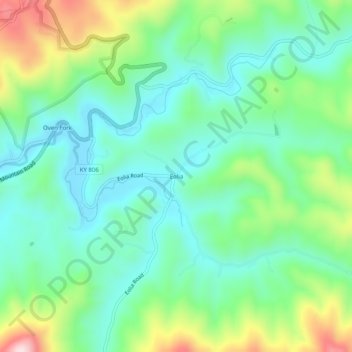
Nombre: Mapa topográfico Eolia, altitud, relieve.
Lugar: Eolia, Letcher County, Kentucky, 40826, United States (37.03371 -82.81155 37.07371 -82.77155)
Altitud media: 612 m
Altitud mínima: 496 m
Altitud máxima: 894 m
Otros mapas topográficos
Haga clic en un mapa para ver su topografía, su altitud y su relieve.
Jenkins
United States > Kentucky > Letcher County
Jenkins, Letcher County, Kentucky, 41517, United States
Altitud media: 590 m
Fleming-Neon
United States > Kentucky > Letcher County
Fleming-Neon, Letcher County, Kentucky, United States
Altitud media: 489 m
Roxana
United States > Kentucky > Letcher County
Roxana, Letcher County, Kentucky, 41832, United States
Altitud media: 425 m
Gordon
United States > Kentucky > Letcher County
Gordon, Letcher County, Kentucky, 40823, United States
Altitud media: 587 m
Whitesburg
United States > Kentucky > Letcher County
Whitesburg, Letcher County, Kentucky, United States
Altitud media: 446 m
Dunham
United States > Kentucky > Letcher County > Jenkins
Dunham, Jenkins, Letcher County, Kentucky, 41835, United States
Altitud media: 563 m
McRoberts
United States > Kentucky > Letcher County
McRoberts, Letcher County, Kentucky, 41835, United States
Altitud media: 572 m
Neon
United States > Kentucky > Letcher County > Fleming-Neon > Neon
Neon, Fleming-Neon, Letcher County, Kentucky, 41840, United States
Altitud media: 486 m
Ermine
United States > Kentucky > Letcher County > Ermine
Ermine, Letcher County, Kentucky, 41837, United States
Altitud media: 447 m