
Mapa topográfico Sawtooth National Forest
Mapa interactivo
Haga clic en el mapa para ver la altitud.
Acerca de este mapa
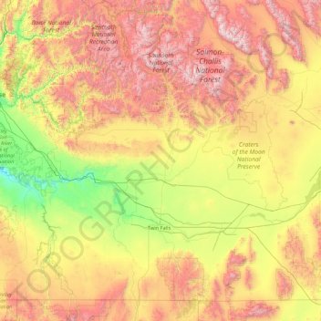
Nombre: Mapa topográfico Sawtooth National Forest, altitud, relieve.
Altitud media: 1.608 m
Altitud mínima: 706 m
Altitud máxima: 3.594 m
About 47 percent of the forest's land is forested, and an additional 3 percent can support trees, but does not currently have any. Lower elevations in Sawtooth National Forest often have sagebrush and grassland vegetation types, while forested areas contain a variety of tree species. Lodgepole pine forms nearly monotypic forests in part of the SNRA with sparse vegetation under the tree cover. Plants that can be found under lodgepole pines include grasses, scattered forbs, dwarf huckleberry, and grouse whortleberry. Douglas-fir and quaking aspen are found in similar environments throughout the forest with understories of low shrubs, such as common snowberry and white spirea.:A-21 Aspen is also found throughout the forest at elevations ranging from 5,000 ft (1,500 m) to 11,000 ft (3,400 m).:A-22