
Mapa topográfico Da Nang
Mapa interactivo
Haga clic en el mapa para ver la altitud.
Acerca de este mapa
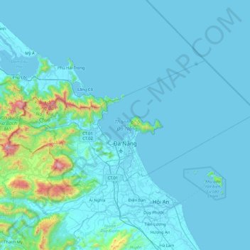
Nombre: Mapa topográfico Da Nang, altitud, relieve.
Lugar: Da Nang, Vietnam (15.91795 107.81878 16.33401 108.65637)
Altitud media: 99 m
Altitud mínima: -2 m
Altitud máxima: 1.662 m
Geologically, Da Nang is at the edge of a Paleozoic fold belt known as the Truong Son Orogenic Zone, whose main deformation occurred during the early Carboniferous period. Da Nang's topography is dominated by the steep Annamite mountain range to the north and north-west, which features peaks ranging from 700 to 1,500 metres (2,300 to 4,900 ft) in height, and low-lying coastal plains with some salting to the south and east, with several white sand beaches along the coast.