
Mapa topográfico Bell Farm
Mapa interactivo
Haga clic en el mapa para ver la altitud.
Acerca de este mapa
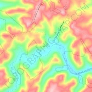
Nombre: Mapa topográfico Bell Farm, altitud, relieve.
Lugar: Bell Farm, McCreary County, Kentucky, United States (36.64969 -84.69496 36.68969 -84.65496)
Altitud media: 369 m
Altitud mínima: 273 m
Altitud máxima: 455 m
Otros mapas topográficos
Haga clic en un mapa para ver su topografía, su altitud y su relieve.
Stearns
United States > Kentucky > McCreary County
Stearns, McCreary County, Kentucky, United States
Altitud media: 392 m
Yamacraw
United States > Kentucky > McCreary County
Yamacraw, McCreary County, Kentucky, 42647, United States
Altitud media: 315 m
Flat Rock
United States > Kentucky > McCreary County
Flat Rock, McCreary County, Kentucky, 42653, United States
Altitud media: 374 m
Strunk
United States > Kentucky > McCreary County > Strunk
Strunk, McCreary County, Kentucky, 42649, United States
Altitud media: 410 m
Pine Knot
United States > Kentucky > McCreary County
Pine Knot, McCreary County, Kentucky, United States
Altitud media: 399 m
Whitley City
United States > Kentucky > McCreary County
Whitley City, McCreary County, Kentucky, 42563, United States
Altitud media: 390 m