
Mapa topográfico Mountlake Terrace
Mapa interactivo
Haga clic en el mapa para ver la altitud.
Acerca de este mapa
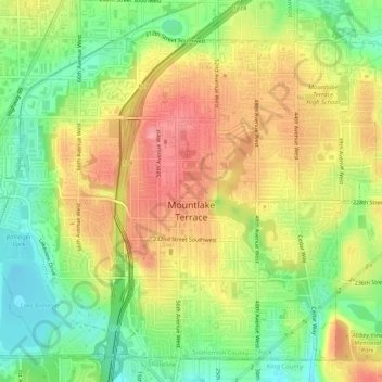
Nombre: Mapa topográfico Mountlake Terrace, altitud, relieve.
Altitud media: 121 m
Altitud mínima: 77 m
Altitud máxima: 162 m
The city sits on a plateau that is elevated from the surrounding landscape, with views of the Olympic and Cascade mountains. The Mountlake Terrace's elevation ranges from 263 to 528 feet (80 to 161 m) above sea level, with an average altitude of 440 feet (130 m). The southwestern portion of the city includes the 100-acre (40 ha) Lake Ballinger, which is fed by Hall Creek from Lynnwood and discharges into McAleer Creek towards Lake Washington. Other portions of Mountlake Terrace lie in the watersheds of Lyon Creek and Swamp Creek, which both drain into Lake Washington.
Otros mapas topográficos
Haga clic en un mapa para ver su topografía, su altitud y su relieve.
Everett
United States > Washington > Snohomish County
Everett, Snohomish County, Washington, United States
Altitud media: 66 m
Sultan
United States > Washington > Snohomish County
Sultan, Snohomish County, Washington, 98294, United States
Altitud media: 78 m