
Mapa topográfico Solferino
Mapa interactivo
Haga clic en el mapa para ver la altitud.
Acerca de este mapa
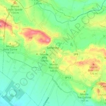
Nombre: Mapa topográfico Solferino, altitud, relieve.
Lugar: Solferino, Mantua, Lombardy, 46040, Italy (45.34248 10.53443 45.38982 10.58191)
Altitud media: 119 m
Altitud mínima: 77 m
Altitud máxima: 198 m
The municipal territory, extending for 13.08 km2, is part of the Morainic amphitheatre of Lake Garda, located a few kilometres to the north. The altitude at the town hall is 124 m above sea level. Not far away also lies the province of Verona, with the towns of Peschiera del Garda and Valeggio sul Mincio, only a few kilometres to the east.
Otros mapas topográficos
Haga clic en un mapa para ver su topografía, su altitud y su relieve.
Volta Mantovana
Italy > Lombardy > Mantua > Volta Mantovana
Volta Mantovana, Mantua, Lombardy, Italy
Altitud media: 73 m
Castiglione delle Stiviere
Italy > Lombardy > Mantua > Castiglione delle Stiviere > Castiglione delle Stiviere
Castiglione delle Stiviere, Mantua, Lombardy, 46043, Italy
Altitud media: 107 m
Sabbioneta
Italy > Lombardy > Mantua > Sabbioneta
Sabbioneta, Mantua, Lombardy, 46018, Italy
Altitud media: 23 m