
Haz una donación
Mapa topográfico Putney
Haga clic en el mapa para ver la altitud.
Haz una donación
Putney
Putney Heath is around 400 acres (160 hectares) less the nascent A3 road in size and rises to 45 metres (148 ft) above sea level. Because of its elevation, from 1796 to 1816 Putney Heath hosted a station in the shutter telegraph chain, which connected the Admiralty in London to its naval ships in Portsmouth. One of 10 signal stations with telescopes making observation of the next station's signal, a message could be sent from the Admiralty to Portsmouth within 15 minutes. This was replaced by a semaphore station, which was part of a semaphore line that operated between 1822 and 1847.
Haz una donación
Acerca de este mapa
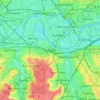
Nombre: Mapa topográfico Putney, altitud, relieve.
Lugar: Putney, Greater London, England, SW15 1RG, United Kingdom (51.42255 -0.25675 51.50255 -0.17675)
Altitud media: 18 m
Altitud mínima: -8 m
Altitud máxima: 59 m
Haz una donación
Otros mapas topográficos
Haga clic en un mapa para ver su topografía, su altitud y su relieve.
Bath
United Kingdom > England > Bath and North East Somerset
Bath is in the Avon Valley and is surrounded by limestone hills as it is near the southern edge of the Cotswolds, a designated Area of Outstanding Natural Beauty, and the Mendip Hills rise around 7 miles (11 km) south of the city. The hills that surround and make up the city have a maximum altitude of 781 feet…
Altitud media: 100 m
Haz una donación
Haz una donación
Ludlow
United Kingdom > England > Shropshire
During the 12th century, the planned town of Ludlow was formed, in stages, the town providing a useful source of income for successive Marcher Lords, based on rents, fines, and tolls. They developed the town on a regular grid pattern, although this was adapted somewhat to match the local topography, from the…
Altitud media: 108 m
Haz una donación
Ashby-de-la-Zouch
United Kingdom > England > Leicestershire > North West Leicestershire
Altitud media: 132 m
Haz una donación
Surrey
United Kingdom > England > Surrey
The highest elevation in Surrey is Leith Hill near Dorking. It is 295 m (968 ft) above sea level and is the second highest point in southeastern England after Walbury Hill in West Berkshire which is 297 m (974 ft).
Altitud media: 69 m
Haz una donación
Haz una donación
Haz una donación
Haz una donación
Haz una donación
Haz una donación
Nottingham Canal
United Kingdom > England > Nottinghamshire > Nottingham > Beeston
Altitud media: 33 m
Haz una donación
Haz una donación
Haz una donación
Ashover CP
United Kingdom > England > Derbyshire > North East Derbyshire
By the 18th century, there were several thousand acres of unenclosed moorland in the parish of Ashover, principally covered with heath. The only paths across this wilderness for roads were tracks in the sand or heath with here and there a stone post on the hills or elevations to serve as guides to the…
Altitud media: 210 m
Haz una donación
Haz una donación
Haz una donación
Haz una donación
North East England
Precipitation is often low by English standards, in spite of the low levels of sunshine, with Stockton-on-Tees averaging only 574.2 millimetres (22.61 in) annually, and with the seaside town of Tynemouth (despite its slightly sunnier climate) recording 597.2 millimetres (23.51 in) annually. The summers on the…
Altitud media: 165 m
Haz una donación
Haz una donación
Bury St Edmunds
United Kingdom > England > Suffolk > West Suffolk
The name Bury is etymologically connected with borough, which has cognates in other Germanic languages such as German Burg 'fortress, castle' and Bereich '(defined) area' Old Norse borg 'wall, castle'; and Gothic baurg 'city'. They all derive from Proto-Germanic *burgs 'fortress'. This in turn derives from the…
Altitud media: 54 m
Haz una donación
Haz una donación
Northampton
United Kingdom > England > West Northamptonshire
As with the rest of the British Isles, Northampton experiences an oceanic climate with cool summers and mild winters. The official Met Office weather station for Northampton is the Moulton Park Weather Station at the University of Northampton. Situated at an elevation of around 130 m (427 ft) above sea level…
Altitud media: 89 m
Haz una donación
Chadlington
United Kingdom > England > Oxfordshire > West Oxfordshire > Charlbury
Altitud media: 161 m
Aylesbury
United Kingdom > England > Buckinghamshire
Aylesbury is immediately southeast of the upper River Thame that flows past Thame to Dorchester on Thames and is partly sited on the two northernmost outcrops of Portland (lime)stone in England bisected by a small stream, Bear Brook which gives a relatively prominent position in relation to the terrain of all…
Altitud media: 85 m
Haz una donación
Haz una donación
Haz una donación