
Haz una donación
Mapa topográfico Ruivo
Haga clic en el mapa para ver la altitud.
Haz una donación
Ruivo
As the highest point in the archipelago, Pico Ruivo is primarily surrounded by high-altitude heath. The area is also marked by monumental rock formations, which often rise above the clouds, dominating the landscape. The region is home to several bird species, including the Madeira firecrest, the chaffinch, and the linnet.
Haz una donación
Acerca de este mapa
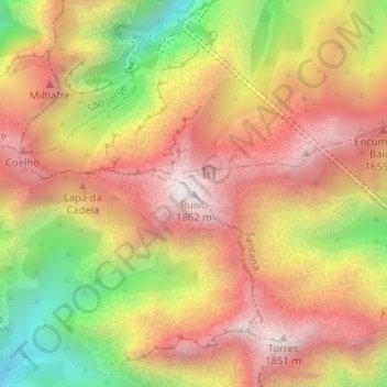
Nombre: Mapa topográfico Ruivo, altitud, relieve.
Lugar: Ruivo, Santana, Madeira, 9230-000, Portugal (32.75883 -16.94281 32.75893 -16.94271)
Altitud media: 1.400 m
Altitud mínima: 798 m
Altitud máxima: 1.837 m
Haz una donación
Otros mapas topográficos
Haga clic en un mapa para ver su topografía, su altitud y su relieve.
São Jorge
Fifty kilometres from the regional capital, the parish is located 240 metres above sea level, limited in the north by the Atlantic Ocean and south by the mountains of the interior range (the heightest altitudes in the parish include Pico Canário 1,592 metres (5,223 ft) and Pico dos Assumadouros 1,184 metres…
Altitud media: 581 m
Haz una donación