
Mapa topográfico Owasco Lake
Mapa interactivo
Haga clic en el mapa para ver la altitud.
Acerca de este mapa
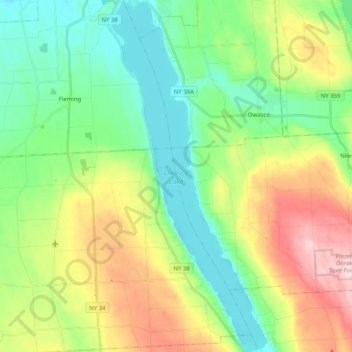
Nombre: Mapa topográfico Owasco Lake, altitud, relieve.
Altitud media: 305 m
Altitud mínima: 208 m
Altitud máxima: 492 m
Owasco Lake is 11.1 miles (17.9 km) long, with a maximum width of 1.3 miles (2.1 km). The lake reaches a maximum depth of 177 feet (54 m) and has a surface elevation of 712 feet (217 m) above sea level, controlled by a dam on the lake's outlet. The lake has a volume of 212 billion US gallons (800,000,000 m3), and drains a watershed of 208 square miles (540 km2).
Otros mapas topográficos
Haga clic en un mapa para ver su topografía, su altitud y su relieve.
Gregory Landing
United States > New York > Cayuga County > Town of Niles
Gregory Landing, Town of Niles, Cayuga County, New York, United States
Altitud media: 356 m
New Hope
United States > New York > Cayuga County > Town of Niles
New Hope, Town of Niles, Cayuga County, New York, United States
Altitud media: 446 m
Omro
United States > New York > Cayuga County > Town of Niles
Omro, Town of Niles, Cayuga County, New York, 13118, United States
Altitud media: 424 m
Globe Hotel Corners
United States > New York > Cayuga County > Town of Niles
Globe Hotel Corners, Town of Niles, Cayuga County, New York, United States
Altitud media: 429 m
Austin
United States > New York > Cayuga County > Town of Niles
Austin, Town of Niles, Cayuga County, New York, United States
Altitud media: 340 m
Partello Corners
United States > New York > Cayuga County > Town of Niles
Partello Corners, Town of Niles, Cayuga County, New York, United States
Altitud media: 423 m
Kelloggsville
United States > New York > Cayuga County > Town of Niles
Kelloggsville, Town of Niles, Cayuga County, New York, United States
Altitud media: 442 m