
Gracias por apoyar a este sitio ❤️
Haz una donación
Haz una donación
Mapa topográfico Strickland Heights
Haga clic en el mapa para ver la altitud.
Gracias por apoyar a este sitio ❤️
Haz una donación
Haz una donación
Acerca de este mapa
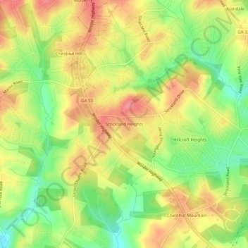
Nombre: Mapa topográfico Strickland Heights, altitud, relieve.
Lugar: Strickland Heights, Hall County, Georgia, United States (34.16733 -83.87018 34.20733 -83.83018)
Altitud media: 325 m
Altitud mínima: 275 m
Altitud máxima: 368 m
Gracias por apoyar a este sitio ❤️
Haz una donación
Haz una donación
Otros mapas topográficos
Haga clic en un mapa para ver su topografía, su altitud y su relieve.
Gracias por apoyar a este sitio ❤️
Haz una donación
Haz una donación
Sterling on the Lake Dam #1
United States > Georgia > Hall County > Flowery Branch
Altitud media: 299 m
Gracias por apoyar a este sitio ❤️
Haz una donación
Haz una donación