
Mapa topográfico Cheaha Mountain
Mapa interactivo
Haga clic en el mapa para ver la altitud.
Acerca de este mapa
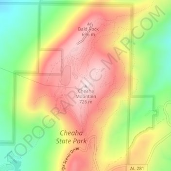
Nombre: Mapa topográfico Cheaha Mountain, altitud, relieve.
Lugar: Cheaha Mountain, Cleburne County, Alabama, United States (33.48557 -85.80883 33.48567 -85.80873)
Altitud media: 543 m
Altitud mínima: 332 m
Altitud máxima: 733 m
The highest point is marked with a USGS benchmark in front of Bunker Tower, a stone Civilian Conservation Corps building with an observation deck on top. The CCC also constructed a road to Cheaha, but the road has been closed for years. The old road is known as CC Road and contains interesting ruins. Near the peak is Bald Rock, which was recently improved with a wheelchair-accessible wooden walkway that provides an impressive overlook of the surrounding region. The entire area gives an impression of being at a much higher elevation than it actually is, in part because of the relatively low elevation of the adjacent area to the west.
Otros mapas topográficos
Haga clic en un mapa para ver su topografía, su altitud y su relieve.
Ai
United States > Alabama > Cleburne County
Ai, Cleburne County, Alabama, United States
Altitud media: 298 m
Abernathy
United States > Alabama > Cleburne County
Abernathy, Cleburne County, Alabama, United States
Altitud media: 296 m
Hollis Crossroads
United States > Alabama > Cleburne County
Hollis Crossroads, Cleburne County, Alabama, United States
Altitud media: 266 m
Liberty Hill
United States > Alabama > Cleburne County
Liberty Hill, Cleburne County, Alabama, United States
Altitud media: 313 m
Abel
United States > Alabama > Cleburne County
Abel, Cleburne County, Alabama, United States
Altitud media: 306 m
Chulafinnee
United States > Alabama > Cleburne County
Chulafinnee, Cleburne County, Alabama, United States
Altitud media: 269 m
Edwardsville
United States > Alabama > Cleburne County
Edwardsville, Cleburne County, Alabama, 36261, United States
Altitud media: 294 m
Ranburne
United States > Alabama > Cleburne County
Ranburne, Cleburne County, Alabama, United States
Altitud media: 303 m
Hopewell
United States > Alabama > Cleburne County
Hopewell, Cleburne County, Alabama, United States
Altitud media: 327 m
Muscadine
United States > Alabama > Cleburne County
Muscadine, Cleburne County, Alabama, 36269, United States
Altitud media: 309 m
Trickem
United States > Alabama > Cleburne County
Trickem, Cleburne County, Alabama, United States
Altitud media: 335 m
Cheaha State Park
United States > Alabama > Cleburne County
Cheaha State Park, Cleburne County, Alabama, United States
Altitud media: 386 m
Heflin
United States > Alabama > Cleburne County
Heflin, Cleburne County, Alabama, United States
Altitud media: 302 m
Fruithurst
United States > Alabama > Cleburne County
Fruithurst, Cleburne County, Alabama, United States
Altitud media: 330 m
Oak Level
United States > Alabama > Cleburne County > Oak Level
Oak Level, Cleburne County, Alabama, United States
Altitud media: 308 m
Fruithurst
United States > Alabama > Cleburne County > Fruithurst
Fruithurst, Cleburne County, Alabama, United States
Altitud media: 330 m