
Mapa topográfico Provo
Mapa interactivo
Haga clic en el mapa para ver la altitud.
Provo
Provo lies on the eastern bank of Utah Lake in Utah Valley at an elevation of 4,549 feet (1,387 m). According to the United States Census Bureau, the city has an area of 44.2 square miles (114.4 km2), of which 41.7 square miles (107.9 km2) is land and 2.5 square miles (6.5 km2), or 5.66%, is water.
Acerca de este mapa
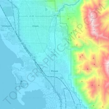
Nombre: Mapa topográfico Provo, altitud, relieve.
Lugar: Provo, Utah County, Utah, United States (40.18580 -111.74096 40.32880 -111.53687)
Altitud media: 1.728 m
Altitud mínima: 1.364 m
Altitud máxima: 3.356 m