
Mapa topográfico Starvation State Park
Mapa interactivo
Haga clic en el mapa para ver la altitud.
Acerca de este mapa
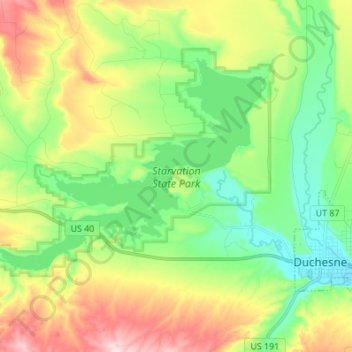
Nombre: Mapa topográfico Starvation State Park, altitud, relieve.
Altitud media: 1.786 m
Altitud mínima: 1.675 m
Altitud máxima: 1.979 m
Otros mapas topográficos
Haga clic en un mapa para ver su topografía, su altitud y su relieve.
Fruitland
United States > Utah > Duchesne County
Fruitland, Duchesne County, Utah, 84027, United States
Altitud media: 2.028 m
Roosevelt
United States > Utah > Duchesne County
Roosevelt, Duchesne County, Utah, 84066, United States
Altitud media: 1.553 m
High Uintas Wilderness
United States > Utah > Duchesne County
High Uintas Wilderness, Duchesne County, Utah, United States
Altitud media: 2.919 m
Kings Peak
United States > Utah > Duchesne County
Kings Peak, Duchesne County, Utah, United States
Altitud media: 3.743 m