
Mapa topográfico Oia
Mapa interactivo
Haga clic en el mapa para ver la altitud.
Acerca de este mapa
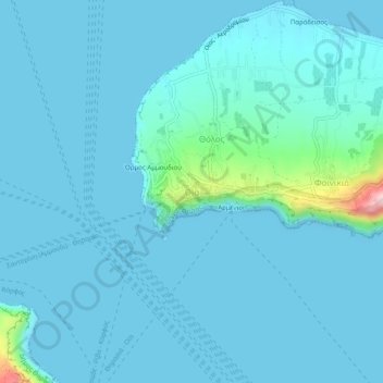
Nombre: Mapa topográfico Oia, altitud, relieve.
Altitud media: 20 m
Altitud mínima: 0 m
Altitud máxima: 251 m
The village is located on top of a hill, at about 150 m (500 ft) elevation, and known as the "Eagles nest" from where Palia and Nea Kameni volcanoes are seen and also the island of Therasia. It is situated to the north of the island and Fira is at distance of 11 km (7 mi). The main street in the town, in the central square, is the main trekking path which is cobbled, called the "Nikalaou Namikaou", which goes up the hill winding round the caldera. The island is reached from Fira which is the transport terminus of the island. Caldera boat cruise options are available from either Oia or Fira.