
Mapa topográfico Guntersville
Mapa interactivo
Haga clic en el mapa para ver la altitud.
Acerca de este mapa
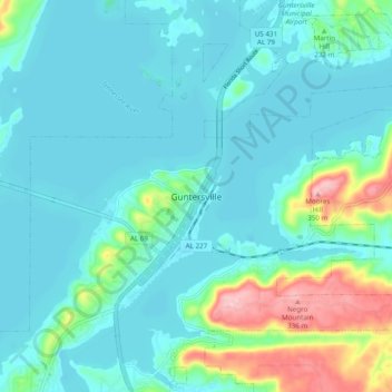
Nombre: Mapa topográfico Guntersville, altitud, relieve.
Lugar: Guntersville, Marshall County, Alabama, 35976, United States (34.31815 -86.33470 34.39815 -86.25470)
Altitud media: 208 m
Altitud mínima: 177 m
Altitud máxima: 346 m
Otros mapas topográficos
Haga clic en un mapa para ver su topografía, su altitud y su relieve.
Lake Guntersville State Park
United States > Alabama > Marshall County > Guntersville
Lake Guntersville State Park, Guntersville, Marshall County, Alabama, United States
Altitud media: 242 m
Lindsay Lane
United States > Alabama > Marshall County > Guntersville
Lindsay Lane, Guntersville, Marshall County, Alabama, 35976, United States
Altitud media: 249 m
Wyeth City
United States > Alabama > Marshall County > Guntersville > Wyeth City
Wyeth City, Guntersville, Marshall County, Alabama, 35976, United States
Altitud media: 230 m