
Mapa topográfico Pathankot
Mapa interactivo
Haga clic en el mapa para ver la altitud.
Acerca de este mapa
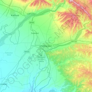
Nombre: Mapa topográfico Pathankot, altitud, relieve.
Altitud media: 379 m
Altitud mínima: 257 m
Altitud máxima: 782 m
Pathankot has an average elevation of 332 metres (1,089 ft). It is a green town surrounded by the Ravi and Chakki rivers. Shiwalik foothills on the south and east and snow-capped Himalayas in the back drop in north.
Otros mapas topográficos
Haga clic en un mapa para ver su topografía, su altitud y su relieve.
Sujanpur
India > Punjab > Pathankot Tahsil
Sujanpur, Pathankot Tahsil, Pathankot District, Punjab, 145023, India
Altitud media: 334 m