
Mapa topográfico Enrile
Mapa interactivo
Haga clic en el mapa para ver la altitud.
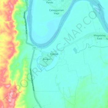
Enrile
Enrile is bounded by hills and mountains on both North and West. Area with low elevation is about 20 meters above sea level at the Eastern part which lies close to the river boundaries. The highest elevation is found Northwest which is approximately 800 meters above sea level.
Acerca de este mapa
Nombre: Mapa topográfico Enrile, altitud, relieve.
Lugar: Enrile, Cagayan, Cagayan Valley, Philippines (17.52176 121.66071 17.60176 121.74071)
Altitud media: 45 m
Altitud mínima: 8 m
Altitud máxima: 188 m