
Mapa topográfico New Lexington
Mapa interactivo
Haga clic en el mapa para ver la altitud.
Acerca de este mapa
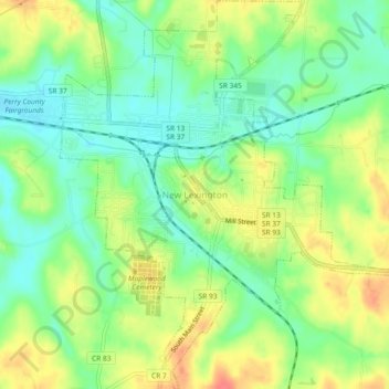
Nombre: Mapa topográfico New Lexington, altitud, relieve.
Lugar: New Lexington, Perry County, Ohio, United States (39.69611 -82.22455 39.73168 -82.18130)
Altitud media: 279 m
Altitud mínima: 255 m
Altitud máxima: 311 m
Otros mapas topográficos
Haga clic en un mapa para ver su topografía, su altitud y su relieve.
New Straitsville
United States > Ohio > Perry County > New Straitsville
New Straitsville, Perry County, Ohio, United States
Altitud media: 278 m