
Mapa topográfico Mueller Glacier
Mapa interactivo
Haga clic en el mapa para ver la altitud.
Acerca de este mapa
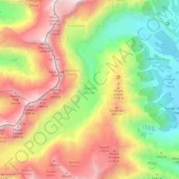
Nombre: Mapa topográfico Mueller Glacier, altitud, relieve.
Altitud media: 1.616 m
Altitud mínima: 723 m
Altitud máxima: 2.622 m
Otros mapas topográficos
Haga clic en un mapa para ver su topografía, su altitud y su relieve.
Mount Cook Village
New Zealand > Canterbury > Mount Cook Village
Mount Cook Village, Mackenzie District, Canterbury, 7946, New Zealand
Altitud media: 984 m
Eugenie Glacier
New Zealand > Canterbury > Mount Cook Village
Eugenie Glacier, Hooker Valley Track, Mount Cook Village, Mackenzie District, Canterbury, 7946, New Zealand
Altitud media: 1.827 m
Red Tarns
New Zealand > Canterbury > Mount Cook Village
Red Tarns, Red Tarns Track, Mount Cook Village, Mackenzie District, Canterbury, 7946, New Zealand
Altitud media: 997 m