
Mapa topográfico Padre Burgos
Mapa interactivo
Haga clic en el mapa para ver la altitud.
Acerca de este mapa
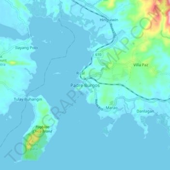
Nombre: Mapa topográfico Padre Burgos, altitud, relieve.
Lugar: Padre Burgos, Quezon, Calabarzon, 4303, Philippines (13.87594 121.77495 13.95594 121.85495)
Altitud media: 19 m
Altitud mínima: -1 m
Altitud máxima: 236 m
On January 1, 1917 the village of Laguimanoc, which was formerly a barrio of Atimonan, became a municipality. Ten years after, the town’s council changed the name to Padre Burgos, in honor of one of the country’s martyrs, Fr. Jose P. Burgos. The streets were named after local leaders who rendered valuable services to the community. Because of the physical and topographic conditions of the town, four sitios where clusters of houses were became the main district of the town namely Campo, Burgos, Basiao and Bundok-Punta. The community converged to be in this particular spot because of its sea which made this town as port of Laguimanoc. In the early days this port offered a good wharf for vessels plying between Manila and southern Luzon. This was also a port of call for ships exporting lumber to Europe during the Spanish regime. In this town was the residence of the “Alcalde Mar” or Port Officer.