
Mapa topográfico Karpenisi
Mapa interactivo
Haga clic en el mapa para ver la altitud.
Acerca de este mapa
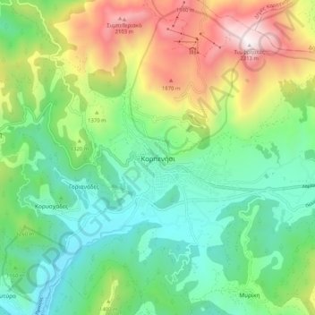
Nombre: Mapa topográfico Karpenisi, altitud, relieve.
Altitud media: 1.236 m
Altitud mínima: 710 m
Altitud máxima: 2.301 m
Karpenisi (Greek: Καρπενήσι, Greek pronunciation: [karpeˈnisi]) is a town in central Greece. It is the capital of the regional unit of Evrytania. Karpenisi is situated in the valley of the river Karpenisiotis (Καρπενησιώτης), a tributary of the Megdovas, in the southern part of the Pindus Mountains. Mount Tymfristos (2,315 m elevation) lies directly to the north of the town, and the foothills of mount Kaliakouda are in the south. Karpenisi has a ski resort and is a popular destination, especially during winter. It is called Switzerland of Greece for the resemblance with the mountainous country and its beauty, atypical for a Mediterranean place.