
Mapa topográfico Bristol
Mapa interactivo
Haga clic en el mapa para ver la altitud.
Acerca de este mapa
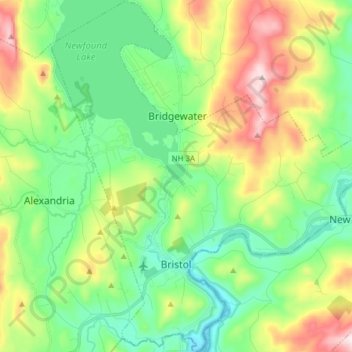
Nombre: Mapa topográfico Bristol, altitud, relieve.
Lugar: Bristol, Grafton County, New Hampshire, 03222, United States (43.56344 -71.79255 43.67518 -71.65108)
Altitud media: 254 m
Altitud mínima: 95 m
Altitud máxima: 580 m
According to the United States Census Bureau, the town has a total area of 21.9 square miles (56.8 km2), of which 16.8 square miles (43.4 km2) are land and 5.2 square miles (13.4 km2) are water, comprising 23.60% of the town. Bristol is drained by the Pemigewasset River (forming the southeastern boundary of the town), the Smith River (on the town's short southern boundary) and the Newfound River, draining Newfound Lake and most of the center of town. The highest point in town is Bristol Peak, elevation 1,803 feet (550 m) above sea level. Bristol lies fully within the Merrimack River watershed.
Otros mapas topográficos
Haga clic en un mapa para ver su topografía, su altitud y su relieve.
Lyman
United States > New Hampshire > Grafton County
Lyman, Grafton County, New Hampshire, United States
Altitud media: 347 m
Warren
United States > New Hampshire > Grafton County
Warren, Grafton County, New Hampshire, United States
Altitud media: 475 m
Bonsai
United States > New Hampshire > Grafton County > Rumney
Bonsai, Rumney, Grafton County, New Hampshire, 03266, United States
Altitud media: 246 m
Franconia
United States > New Hampshire > Grafton County
Franconia, Grafton County, New Hampshire, 03580, United States
Altitud media: 558 m
Waterville Valley
United States > New Hampshire > Grafton County
Waterville Valley, Grafton County, New Hampshire, 03215, United States
Altitud media: 649 m
Groton
United States > New Hampshire > Grafton County
Groton, Grafton County, New Hampshire, United States
Altitud media: 366 m
Plymouth
United States > New Hampshire > Grafton County
Plymouth, Grafton County, New Hampshire, 03264, United States
Altitud media: 264 m
Wentworth
United States > New Hampshire > Grafton County
Wentworth, Grafton County, New Hampshire, 03282, United States
Altitud media: 422 m
Bath
United States > New Hampshire > Grafton County
Bath, Grafton County, New Hampshire, 03740, United States
Altitud media: 289 m
North Haverhill
United States > New Hampshire > Grafton County > Haverhill
North Haverhill, Haverhill, Grafton County, New Hampshire, 03774, United States
Altitud media: 149 m
Echo Lake
United States > New Hampshire > Grafton County > Franconia
Echo Lake, Franconia, Grafton County, New Hampshire, United States
Altitud media: 693 m
Stinson Lake
United States > New Hampshire > Grafton County > Rumney > Stinson Lake
Stinson Lake, Rumney, Grafton County, New Hampshire, United States
Altitud media: 460 m
Lebanon
United States > New Hampshire > Grafton County
Lebanon, Grafton County, New Hampshire, United States
Altitud media: 274 m
Mount Kineo, East Peak
United States > New Hampshire > Grafton County > Ellsworth
Mount Kineo, East Peak, Ellsworth, Grafton County, New Hampshire, United States
Altitud media: 710 m
Etna
United States > New Hampshire > Grafton County > Hanover
Etna, Hanover, Grafton County, New Hampshire, 03750, United States
Altitud media: 296 m
Holderness
United States > New Hampshire > Grafton County
Holderness, Grafton County, New Hampshire, 03245, United States
Altitud media: 252 m
Enfield
United States > New Hampshire > Grafton County
Enfield, Grafton County, New Hampshire, United States
Altitud media: 366 m
Sugar Hill
United States > New Hampshire > Grafton County > Sugar Hill
Sugar Hill, Grafton County, New Hampshire, 03586, United States
Altitud media: 372 m
Mount Agassiz
United States > New Hampshire > Grafton County > Bethlehem
Mount Agassiz, Bethlehem, Grafton County, New Hampshire, 03574, United States
Altitud media: 558 m
Littleton
United States > New Hampshire > Grafton County > Littleton
Littleton, Grafton County, New Hampshire, United States
Altitud media: 360 m
North Littleton
United States > New Hampshire > Grafton County > Littleton > North Littleton
North Littleton, Littleton, Grafton County, New Hampshire, United States
Altitud media: 333 m
West Lebanon
United States > New Hampshire > Grafton County > Lebanon > West Lebanon
West Lebanon, Lebanon, Grafton County, New Hampshire, 03784, United States
Altitud media: 165 m
Lebanon
United States > New Hampshire > Grafton County > Lebanon
Lebanon, Grafton County, New Hampshire, 03766-1355, United States
Altitud media: 315 m
LeBruns Mobile Home Park
United States > New Hampshire > Grafton County > Lebanon > LeBruns Mobile Home Park
LeBruns Mobile Home Park, Lebanon, Grafton County, New Hampshire, United States
Altitud media: 326 m
Thornton
United States > New Hampshire > Grafton County
Thornton, Grafton County, New Hampshire, United States
Altitud media: 474 m
Bethlehem
United States > New Hampshire > Grafton County > Bethlehem
Bethlehem, Grafton County, New Hampshire, 03574, United States
Altitud media: 528 m
Easton
United States > New Hampshire > Grafton County
Easton, Grafton County, New Hampshire, United States
Altitud media: 586 m
Lincoln
United States > New Hampshire > Grafton County
Lincoln, Grafton County, New Hampshire, 03251, United States
Altitud media: 677 m
Lyme
United States > New Hampshire > Grafton County
Lyme, Grafton County, New Hampshire, United States
Altitud media: 297 m
Orford
United States > New Hampshire > Grafton County
Orford, Grafton County, New Hampshire, United States
Altitud media: 300 m