
Mapa topográfico Eagle Mountain
Mapa interactivo
Haga clic en el mapa para ver la altitud.
Acerca de este mapa
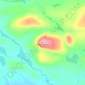
Nombre: Mapa topográfico Eagle Mountain, altitud, relieve.
Lugar: Eagle Mountain, Cook County, Minnesota, United States (47.89737 -90.56039 47.89747 -90.56029)
Altitud media: 596 m
Altitud mínima: 545 m
Altitud máxima: 697 m
Eagle Mountain is only about 15 miles (24 km) from Minnesota's lowest elevation, Lake Superior, at 600 feet (183 m). It is part of the Canadian Shield. Confusingly, there is another much shorter peak also named Eagle Mountain in northern Minnesota. The shorter peak is part of the Lutsen Mountains ski resort.
Otros mapas topográficos
Haga clic en un mapa para ver su topografía, su altitud y su relieve.
West Cook
United States > Minnesota > Cook County
West Cook, Cook County, Minnesota, 55604, United States
Altitud media: 501 m
Schroeder Township
United States > Minnesota > Cook County
Schroeder Township, Cook County, Minnesota, United States, Magic Lake
Altitud media: 564 m
Tent Lake
United States > Minnesota > Cook County
Tent Lake, Cook County, Minnesota, United States
Altitud media: 569 m
Fan Lake
United States > Minnesota > Cook County
Fan Lake, Cook County, Minnesota, United States
Altitud media: 535 m
Lutsen
United States > Minnesota > Cook County
Lutsen, Cook County, Minnesota, 55612, United States
Altitud media: 225 m
Olso Lake
United States > Minnesota > Cook County
Olso Lake, West Cook, Cook County, Minnesota, United States
Altitud media: 544 m
Grand Marais
United States > Minnesota > Cook County
Grand Marais, Cook County, Minnesota, United States
Altitud media: 280 m