
Haz una donación
Mapa topográfico Samar
Haga clic en el mapa para ver la altitud.
Haz una donación
Acerca de este mapa
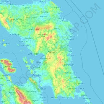
Nombre: Mapa topográfico Samar, altitud, relieve.
Lugar: Samar, Eastern Visayas, Philippines (11.01161 124.26098 12.58474 125.76350)
Altitud media: 76 m
Altitud mínima: -2 m
Altitud máxima: 1.232 m
Haz una donación
Otros mapas topográficos
Haga clic en un mapa para ver su topografía, su altitud y su relieve.
Baguio
In 1903, Filipinos, Japanese and Chinese workers were hired to build Kennon Road, the first road directly connecting Baguio with the lowlands of La Union and Pangasinan. Before this, the only road to Benguet was Naguilian Road, and it was largely a horse trail at higher elevations. Camp John Hay was…
Altitud media: 881 m
Ilagan
Abuan River is the main river of the Northern Sierra Madre Natural Park. It has an average elevation of 82 meters above sea level, and feeds the Abuan watershed in the city. Tourists and visitors can explore the diverse animal and plant life in one of the country’s remaining lush virgin forests. On January…
Altitud media: 123 m
Haz una donación
Quezon City
Founded as a pueblo by Saint Pedro Bautista in 1590, San Francisco del Monte may be considered Quezon City's oldest district. The original land area of the old town of San Francisco del Monte was approximately2.5 square kilometres (1.0 sq mi) and covered parts of what is currently known as Project 7 and 8 and…
Altitud media: 57 m
Haz una donación
Zamboanga City
Philippines > Zamboanga Peninsula > Zamboanga City
The overall topography of the city could be described as rolling to very steep. There are some flat lands, mostly narrow strips along the east coast. The urban center is mostly flat with a gentle slope to the interior, ranging from 0 to 3%. The highest registered elevation is 1,200 metres. In terms of slope, a…
Altitud media: 83 m
Haz una donación
Haz una donación
Muñoz
Muñoz is situated 30 kilometres (19 mi) from Cabanatuan, 44 kilometres (27 mi) from Palayan, and 146 kilometres (91 mi) north of the capital Manila. Due to its rich topography and tropical climate, it is now home to agricultural research and technology centers, committed to the production of information and…
Altitud media: 86 m
Badoc
The celebrated Philippine painter Juan Luna was baptized in Badoc Church on 27 October 1857. At present, the church houses the miraculous statue of the Blessed Virgin Mary venerated under the title Virgin of Miracles, crowned by Catholic bishops in 1980, and was granted a Canonical coronation by Pope Francis…
Altitud media: 20 m
Haz una donación
Haz una donación
Haz una donación
Haz una donación
Haz una donación
Cabadbaran
Philippines > Agusan del Norte
It is 29 kilometres (18 mi) from Butuan. It is generally flat with rolling hills and swamplands in its western part. The highest of all mountains in the Caraga region, Mount Hilong-Hilong (with an altitude of 2,012 metres (6,601 ft) above sea level), rises in this city.
Altitud media: 179 m
Haz una donación
Haz una donación
Bantay
It has an average elevation of 100 meters (328.08 feet), with a land area of 7,660 hectares (18,900 acres). It is an elevated and hilly municipality but some barangays, especially those near creeks, are prone to flooding during heavy typhoons.
Altitud media: 8 m
Haz una donación
Haz una donación
Haz una donación
Haz una donación
Haz una donación
Haz una donación
Haz una donación
Haz una donación
Haz una donación
Haz una donación
Haz una donación
Valenzuela
The highest elevation point is 38 meters (125 ft) above sea level. Having a surface gradient of 0.55% and a gentle slope, hilly landscape is located in the industrial section of the city in Canumay. The average elevation point is 2 meters (6.6 ft) above sea level.
Altitud media: 24 m
Haz una donación
Haz una donación
Haz una donación