
Mapa topográfico Cary
Mapa interactivo
Haga clic en el mapa para ver la altitud.
Acerca de este mapa
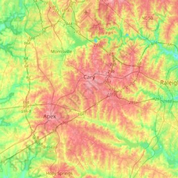
Nombre: Mapa topográfico Cary, altitud, relieve.
Lugar: Cary, Wake County, North Carolina, United States (35.64438 -78.95380 35.89688 -78.72946)
Altitud media: 111 m
Altitud mínima: 60 m
Altitud máxima: 160 m
Cary is seated on the boundary between the Durham Basin with its softer sedimentary rocks and the piedmont with its harder metamorphic rocks; both geologic provinces have igneous rock intrusions. The landscape is typically gentle to moderate sloping hills separated by narrow V-shaped valleys, but there are areas with steeper slopes and broader, U-shaped valleys in western Cary, roughly along NC 55 near the Research Triangle Park and north of Green Hope School Road. Cary's average elevation is 495 ft (151 m).
Otros mapas topográficos
Haga clic en un mapa para ver su topografía, su altitud y su relieve.
Raleigh
United States > North Carolina > Wake County
Raleigh, Wake County, North Carolina, United States
Altitud media: 103 m
Apex
United States > North Carolina > Wake County
Apex, Wake County, North Carolina, 27502, United States
Altitud media: 115 m
Garner
United States > North Carolina > Wake County
Garner, Wake County, North Carolina, United States
Altitud media: 94 m