
Haz una donación
Mapa topográfico Marble Hill
Haga clic en el mapa para ver la altitud.
Haz una donación
Acerca de este mapa
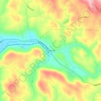
Nombre: Mapa topográfico Marble Hill, altitud, relieve.
Lugar: Marble Hill, Pickens County, Georgia, 30177, United States (34.41069 -84.35688 34.45069 -84.31688)
Altitud media: 404 m
Altitud mínima: 307 m
Altitud máxima: 502 m
Haz una donación
Otros mapas topográficos
Haga clic en un mapa para ver su topografía, su altitud y su relieve.
Jasper
United States > Georgia > Pickens County
Jasper was founded in 1853 as seat of the newly formed Pickens County. It was incorporated in 1857 as a town and in 1957 as a city. The community is named for William Jasper, a hero of the American Revolutionary War. Jasper is situated at an elevation of 1,463 feet (446 m).
Altitud media: 408 m
Haz una donación