
Mapa topográfico Taüll
Mapa interactivo
Haga clic en el mapa para ver la altitud.
Acerca de este mapa
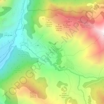
Nombre: Mapa topográfico Taüll, altitud, relieve.
Altitud media: 1.707 m
Altitud mínima: 1.115 m
Altitud máxima: 2.498 m
Located at an altitude of 1,520 meters in the Sant Martí valley, a small valley in the Valley of Boí. The closest river is the Sant Martí river, Noguera de Tor affluent. A ravine splits the village in two districts: La Guinsa and Lo Barri. La Guinsa goes from the entrance of the village to the ravine, and Lo Barri goes from the ravine to the high part of the village.
Otros mapas topográficos
Haga clic en un mapa para ver su topografía, su altitud y su relieve.
Erill la Vall
Spain > Catalonia > Alta Ribagorça > la Vall de Boí > Boí
Erill la Vall, Boí, la Vall de Boí, Alta Ribagorça, Catalonia, 25528, Spain
Altitud media: 1.599 m