
Haz una donación
Mapa topográfico Winston
Haga clic en el mapa para ver la altitud.
Haz una donación
Acerca de este mapa
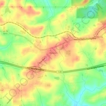
Nombre: Mapa topográfico Winston, altitud, relieve.
Lugar: Winston, Douglas County, Georgia, United States (33.70511 -84.84494 33.74511 -84.80494)
Altitud media: 340 m
Altitud mínima: 295 m
Altitud máxima: 378 m
Haz una donación
Otros mapas topográficos
Haga clic en un mapa para ver su topografía, su altitud y su relieve.
Douglasville
United States > Georgia > Douglas County
Located along a natural rise in the topography, Douglasville was originally known as "Skint Chestnut." The name was derived from a large tree used by Native Americans as a landmark; it was stripped of its bark so as to be more conspicuous.
Altitud media: 310 m