
Mapa topográfico Lenexa
Mapa interactivo
Haga clic en el mapa para ver la altitud.
Acerca de este mapa
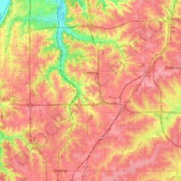
Nombre: Mapa topográfico Lenexa, altitud, relieve.
Lugar: Lenexa, Johnson County, Kansas, United States (38.91504 -94.90896 38.99292 -94.70503)
Altitud media: 301 m
Altitud mínima: 233 m
Altitud máxima: 335 m
Otros mapas topográficos
Haga clic en un mapa para ver su topografía, su altitud y su relieve.
Fairway
United States > Kansas > Johnson County
Fairway, Johnson County, Kansas, United States
Altitud media: 290 m
Overland Park
United States > Kansas > Johnson County
Overland Park, Johnson County, Kansas, United States
Altitud media: 300 m
Lenexa
United States > Kansas > Johnson County > Lenexa
Lenexa, Johnson County, Kansas, 66219, United States
Altitud media: 290 m
Leawood
United States > Kansas > Johnson County
Leawood, Johnson County, Kansas, United States
Altitud media: 289 m
Overland Park
United States > Kansas > Johnson County > Overland Park
Overland Park, Johnson County, Kansas, 66204, United States
Altitud media: 288 m
Prairie Village
United States > Kansas > Johnson County
Prairie Village, Johnson County, Kansas, United States
Altitud media: 300 m
Olathe
United States > Kansas > Johnson County > Olathe
Olathe, Johnson County, Kansas, 66061, United States
Altitud media: 302 m
Olathe
United States > Kansas > Johnson County
Olathe, Johnson County, Kansas, United States
Altitud media: 309 m