
Mapa topográfico Sengscheid
Mapa interactivo
Haga clic en el mapa para ver la altitud.
Acerca de este mapa
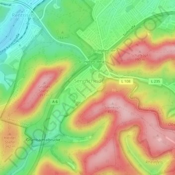
Nombre: Mapa topográfico Sengscheid, altitud, relieve.
Lugar: Sengscheid, St. Ingbert, Saarpfalz-Kreis, Saarland, Deutschland (49.24563 7.07944 49.26383 7.10821)
Altitud media: 303 m
Altitud mínima: 206 m
Altitud máxima: 401 m
Otros mapas topográficos
Haga clic en un mapa para ver su topografía, su altitud y su relieve.
St. Ingbert-Mitte
Deutschland > Saarland > St. Ingbert
St. Ingbert-Mitte, St. Ingbert, Saarpfalz-Kreis, Saarland, 66386, Deutschland
Altitud media: 292 m