
Mapa topográfico Titley
Haga clic en el mapa para ver la altitud.
Acerca de este mapa
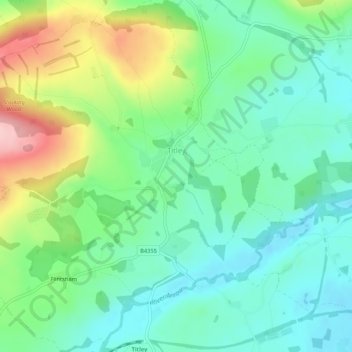
Nombre: Mapa topográfico Titley, altitud, relieve.
Lugar: Titley, Herefordshire, England, United Kingdom (52.21631 -3.01633 52.24850 -2.96407)
Altitud media: 178 m
Altitud mínima: 121 m
Altitud máxima: 305 m
Otros mapas topográficos
Haga clic en un mapa para ver su topografía, su altitud y su relieve.
Bagpiper's Tump
United Kingdom > England > Herefordshire > Mordiford > Bagpiper's Tump
Altitud media: 88 m
Eastnor Deer Park
United Kingdom > England > Herefordshire > Eastnor > Wayend Street
Altitud media: 134 m
Hergest Ridge
United Kingdom > England > Herefordshire
Hergest Ridge is a large elongated hill which traverses the border between England and Wales in the United Kingdom, between the town of Kington in Herefordshire and the village of Gladestry in Powys. Its highest point, which is in England, is 426 metres (1,398 ft) high. It has a topographic prominence of 157.6…
Altitud media: 308 m