
Mapa topográfico Lago Vista
Mapa interactivo
Haga clic en el mapa para ver la altitud.
Lago Vista
According to the United States Census Bureau, the city has a total area of 15.52 sq mi (40.2 km2) of which 14.6 sq mi (38 km2) is land and 0.6 sq mi (1.6 km2) (3.95%) is water. The peninsular city sits adjacent to, and partially within, the Balcones Canyonlands. Lago Vista has rugged terrain with elevations ranging from 774 ft (236 m) above sea level at the lake shore to 1220 ft (372 m) above sea level near Rusty Allen Airport. The area is characterized by steep limestone hills and canyons, some of the highest in Travis County.
Acerca de este mapa
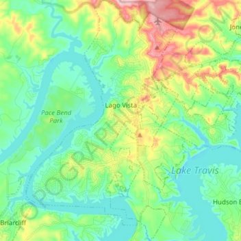
Nombre: Mapa topográfico Lago Vista, altitud, relieve.
Lugar: Lago Vista, Travis County, Texas, United States (30.39919 -98.03744 30.50717 -97.95484)
Altitud media: 251 m
Altitud mínima: 196 m
Altitud máxima: 388 m